20210628_194803

Experimental Site for Permanent Monitoring of the
Poggio Baldi landslide

The Poggio Baldi landslide is one of the largest rock and debris phenomena in the Emilia-Romagna Apennines.

From October 26, 2021 it becomes a real Experimental Permanent Monitoring Site where monitoring activities and advanced remote sensing techniques are merged in a Natural Laboratory. On that day, the site was inaugurated in the presence of the Magnificent Rector.

The Poggio Baldi landslide is one of the largest debris-flow phenomena in the Emilia-Romagna Apennines. With an estimated volume of 4 million cubic meters, the landslide affected, during its last reactivation on March 18, 2010, the village of Poggio Baldi (on the hydrographic left of the Bidente river, in the municipality of Santa Sofia, province of Forlì-Cesena). This event caused numerous damages to the surrounding private houses and infrastructures, causing also the natural damming of the Bidente river. Considered as the reactivation of a more ancient landslide movement, occurred in March 1914, the 2010 event was triggered by the increase of the water pressure in the ground, probably related to a rapid melting of the snow cover accumulated during the winter period. Since 2010, immediately after the event, geological, geomorphological and geomechanical site surveys have been carried out in order to deepen the knowledge of the complex kinematics of the landslide. Moreover, several monitoring activities have been carried out, using both field techniques (inclinometers, strain gauges, piezometers) and remote monitoring (laser, radar, photogrammetry and GNSS). Thanks to the joint contribution of the Department of Earth Sciences of Sapienza University of Rome, NHAZCA S.r.l. startup of Sapienza University of Rome, the National Park of Casentino Forests, Mount Falterona and Campigna, the Municipality of Santa Sofia and Romagna Acque – Società delle Fonti S.p.A., it has been possible to establish a real Experimental Monitoring Site in the area of Poggio Baldi. Here, monitoring activities and advanced remote sensing techniques are combined in a real field laboratory.

PB2

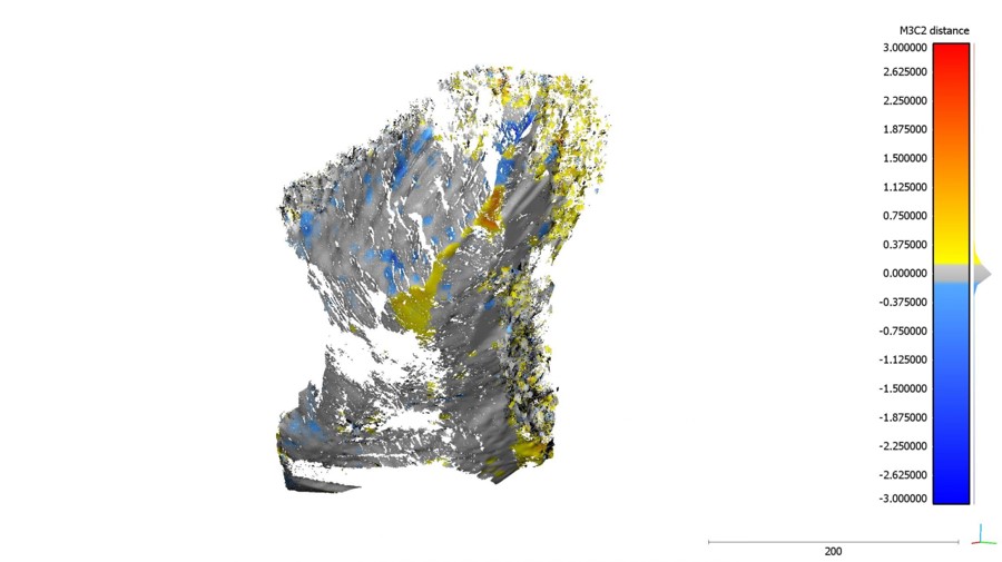
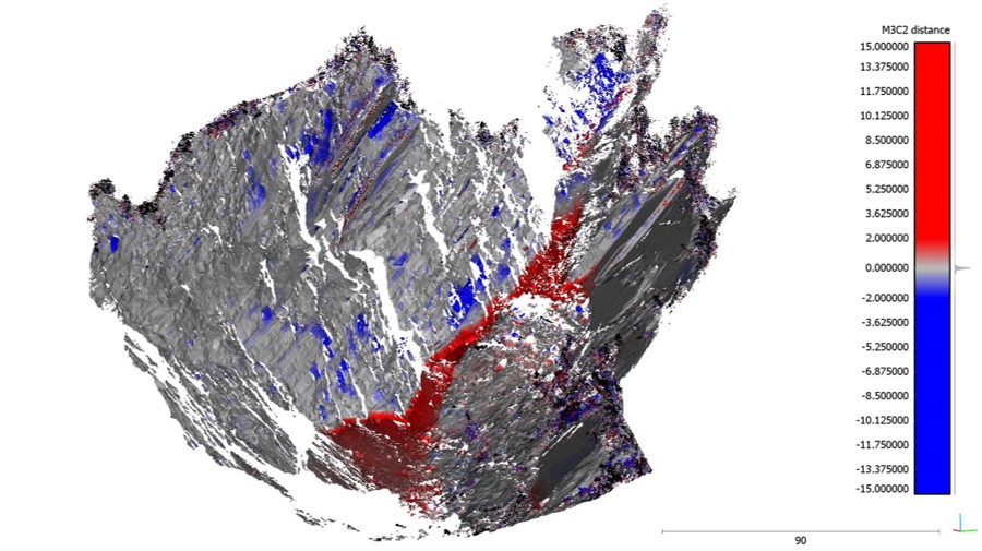
At the moment the sub-vertical slope is about 100 meters high and 250 meters wide and it is characterized by frequently rock-fall processes. These roks and the debris at the end of the landslide represent one of the main morphological elements that characterize the area of the Poggio Baldi. Rock-fall collapses are very frequent on the steepest slopes of mountainous areas and on marine cliffs. Since collapses are the most rapid type of landslide (Varnes, 1978), their impact energy, and therefore the hazard associated with them, can reach very high values.

The many aspects that need analysis, from the evaluation of the geostatic equilibrium of the blocks, to the prediction of the propagation trajectories of the boulders, make rockfalls complex phenomena to study and predict. The trajectory of a falling rock depends on a number of factors whose uncertainty is predominant: the location of the area of detachment, the structural conditions of the boulder in that area, the geometry of the boulder, the mechanical properties of the rock and slope, and the topography (Ritchie, 1963). These factors are difficult to verify in the field and should be determined exactly. The monitoring of rock faces through remote sensing, therefore, is the most suitable and effective tool to date to obtain, in a comprehensive manner, information allowing a thorough identification of the above factors. In Italy and in other parts of the world, in fact, rock collapses are the main cause of landslide victims.

Since 2015 at the Poggio Baldi Experimental Site, many researchers and leading companies in the production of geotechnical and geomatic monitoring instrumentation have been meeting annually with the technical and scientific community for live, in-field demonstrations of their technologies. Moreover, in the Poggio Baldi area a large number of surveys and investigations have been carried out using modern remote sensing techniques, in order to acquire as much information as possible about the Experimental Site. Specifically, the activities carried out were as follows:

  • multi-temporal and multi-station surveys with Terrestrial Laser Scanner (TLS);
  • surveys by Global Navigation Satellite System (GNSS);
  • photogrammetric surveys by SAPR platform (Remotely Piloted Aircraft Systems);
  • Gigapixel surveys by robotic head for camera;
  • monitoring by Terrestrial SAR Interferometry (TInSAR). 

More recently, in 2021, a full-fledged, energy-independent, experimental permanent monitoring site has been established, with the creation of a base of operations for continuous monitoring, remotely accessible and manageable, through the use of various tools, including:

  • optical monitoring system using a permanent PhotoMonitoringTM station;
  • a high sensitivity acoustic monitoring system;
  • radar monitoring system;
  • meteorological station.

Papers

DATE

TITLE

2021

Fold architecture predisposing deep-seated gravitational slope deformations within a flysch sequence in the Northern Apennines (Italy)

Esposito C.; Di Luzio E.; Baleani M.; Troiani F.; Della Seta M.; Bozzano F.; Mazzanti P. (Geomorphology– ELSEVIER)

2021

Short-term geomorphological evolution of the Poggio Baldi landslide upper scarp via 3D change detection

Mazzanti P.; Caporossi P.; Brunetti A.; Mohammadi F.I.; Bozzano F. (Landslides– Springer Nature)

2021

2017

Experimental Landslide Monitoring Site of Poggio Baldi Landslide (Santa Sofia, N-Apennine, Italy)

Mazzanti, Paolo; Bozzano, Francesca; Brunetti, Alessandro; Caporossi, Paolo; Esposito, Carlo; Scarascia Mugnozza, Gabriele (Advancing Culture Of Living With Landslides– Springer Nature)

Team

Paolo Mazzanti

Professor at the Department of Earth Sciences of "Sapienza" University of Rome and CEO of NHAZCA S.r.l. Expert of innovative monitoring solutions in the field of remote sensing, promoter of the international IcGSM course on geotechnical and structural monitoring.

Gabriele Scarascia Mugnozza

Professor at the Department of Earth Sciences of "Sapienza" University of Rome, founding partner of NHAZCA S.r.l., Director of CERI Research Center and President of the National Commission for Major Risks.

Francesca Bozzano

Professor at the Department of Earth Sciences of "Sapienza" University of Rome, president and founding partner of NHAZCA S.r.l., member of the National Commission for forecasting and prevention of major hazards and of the Board of Directors of INGV.

Saverio Romeo

Researcher at the Department of Earth Sciences of "Sapienza" University of Rome and National President of LARES Italy - Italian Union of Experts in Civil Protection, Association of Social Promotion active in the field of Civil Protection.

Antonio Cosentino

Industrial PhD of the 36th Cycle at the Department of Earth Sciences of "Sapienza" University of Rome and co-financed by Nhazca Srl, Start-Up of the same University.

Andrea Massi

Industrial PhD of the 36th Cycle at the Department of Earth Sciences of "Sapienza" University of Rome and co-financed by Nhazca Srl, Start-Up of the same University.

Giandomenico Mastroantoni

Industrial PhD of the 36th Cycle at the Department of Earth Sciences of "Sapienza" University of Rome.

Experimental Site of Permanent Monitoring of the Poggio Baldi landslide