ENIGMA is part of the National Program for Research in Antarctica – PNRA. The objective of the project is to determine the main physical characteristics and model the behavior of the entire Boulder Clay glacier (Antarctica) through the integration of geophysical surveys and the analysis of satellite images. ENIGMA is funded by MIUR.
Recent researches on hydrographic networks and lakes buried under the ice sheet of the Antarctic ice cap have shown a continent that has regions characterized by the presence of a real hydrographic network and water collection areas.
The ENIGMA project, thanks to the synergy of an interdisciplinary study, aims at determining and investigating in detail:
- the main physical characteristics of the Boulder Clay Glacier and model its state of activity through the integration of geophysical surveys and satellite image analysis;
- the presence or not of a possible new deep subglacial lake that, after verification of the boundary conditions, could represent an environment that remained isolated for a period of about 20,000 years;
- the presence of other points in the glacier under investigation where liquid water is found at the ice/bedrock interface;
- the geophysical survey of Lake Enigma (and other lake types present on the Boulder Clay glacier), and its biological and microbiological sampling;
- the feasibility study to realize a sterile ice drilling system to collect water and sediment samples from the new lake in order to determine the microbial communities that inhabit it.
This ambitious project consists of a multidisciplinary team divided into four research units that collaborate from different fronts to provide data and constraints necessary for a complex analysis. The technical units are: the team for the execution of geophysical surveys on the glacier area, the team of multi-temporal SAR image analysis, the team of numerical modeling, the team for the feasibility study of a machine to drill ice with sterile access.
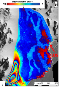
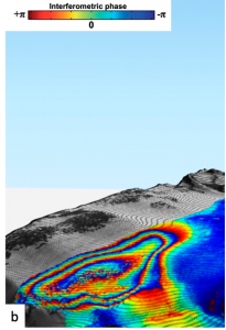
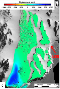
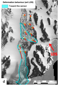
Multi-temporal SAR image analysis is necessary and useful to study the surface deformation pattern of the Boulder Clay Glacier and the adjacent glacial moraine in order to define spatio-temporal correlations and cause-effect relationships. Through the use of multi-temporal image stacks, acquired in the same orbital geometry, we apply A-DInSAR (Advanced Differential Synthetic Aperture Radar) processing methodologies able to return deformation trends with millimetric accuracy. Experimental analyses are also carried out exploiting in an integrated way both phase and radiometric values of SAR images, with the aim of characterizing in detail the surface evolution recorded at monthly, seasonal and annual level on the surface of Lake Ice Blisters. This type of analysis allows to verify their degree of activity and eventual “seasonality” and to check if there are correlations with weather and climate conditions.